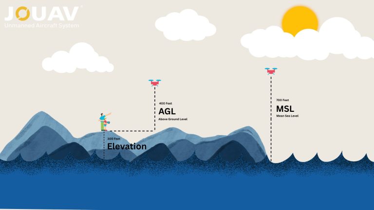
Synthetic Aperture Radar (SAR) is a revolutionary technology that has transformed the way we perceive and interact with our planet.

By emitting radar waves and processing the reflected signals, SAR systems create detailed images of the Earth's surface, regardless of weather conditions or time of day.

This capability has made SAR an indispensable tool for a wide range of applications, from military surveillance and disaster response to agriculture and environmental monitoring.

In this article, we'll dive deep into the world of SAR, exploring how it works, its incredible applications, and the impact it has on our lives.

What is Synthetic Aperture Radar (SAR)?

What is Synthetic Aperture Radar (SAR)?

Synthetic Aperture Radar (SAR) is a sophisticated remote sensing technique capable of producing high-resolution images of the Earth's surface, irrespective of weather conditions or time of day.

Unlike traditional optical remote sensing, which relies on reflected sunlight, SAR employs active illumination using microwave energy.

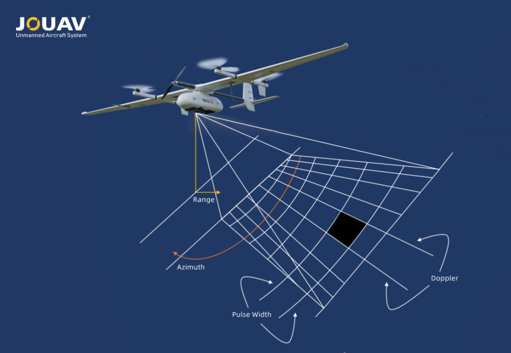
The fundamental concept underlying SAR is the creation of a synthetic aperture. Rather than utilizing a physically large antenna, SAR employs a smaller antenna mounted on a moving platform, such as an aircraft or satellite.

As the platform moves, the antenna continuously transmits and receives microwave pulses.

Through advanced signal processing, these individual measurements are combined to simulate a much larger, virtual antenna, hence the term "synthetic aperture."

SAR image

How Does SAR Work?

How Does SAR Work?

To create a SAR image, a series of microwave pulses are transmitted toward the target area. The reflected energy, or echoes, are received by the antenna and recorded.

As the platform moves, the antenna's position relative to the target changes, capturing multiple perspectives of the same scene.

Through complex signal processing algorithms, the recorded echoes are combined to form a coherent image.

This process involves phase information, which is crucial for reconstructing the target's spatial distribution.

The resulting SAR image provides a detailed representation of the Earth's surface, with information about topography, land cover, and even subsurface features.

How does SAR work

Advantages of SAR Imagery

Advantages of SAR Imagery

SAR offers several distinct advantages over traditional optical remote sensing:

  • All-weather imaging: SAR's ability to penetrate clouds, fog, and smoke makes it invaluable for monitoring and surveillance in challenging weather conditions. This is particularly useful for disaster response, environmental monitoring, and military applications.
  • Day and night operation: Unlike optical sensors reliant on sunlight, SAR generates its own illumination, enabling continuous monitoring regardless of time of day.
  • High resolution: Modern SAR systems can achieve exceptional spatial resolution, allowing for detailed observation of small objects and features on the Earth's surface. This is crucial for applications like urban planning, agriculture, and disaster assessment.
  • Penetration of foliage and soil: SAR's longer wavelengths can partially penetrate vegetation, revealing underlying terrain and structures. This capability is beneficial for forestry, agriculture, and archaeological studies. Additionally, SAR can penetrate dry soil to some extent, providing insights into subsurface features.
  • High revisit rate: SAR satellites can frequently revisit the same area, enabling monitoring of dynamic processes like urban expansion, deforestation, and disaster recovery.
  • No sun glint: SAR is unaffected by sun glint, which can obscure details in optical imagery, especially over water bodies.
Disadvantages of SAR Imagery

Disadvantages of SAR Imagery

While SAR offers numerous advantages, it also has limitations:

  • Complex interpretation: SAR images can be challenging to interpret due to speckle noise and the complex interaction of radar waves with different surface materials. Specialized expertise and processing techniques are often required.
  • Sensitivity to surface properties: The appearance of SAR images is influenced by surface roughness, moisture content, and composition, making image analysis more complex in heterogeneous environments.
  • Limited penetration depth: Although SAR can penetrate clouds and vegetation, its ability to penetrate solid materials like rock or concrete is limited.
  • Prior knowledge required: Unlike optical images, SAR images do not directly represent visual appearance. Understanding the target and its characteristics is essential for accurate interpretation.
  • Lack of color information: SAR imagery is grayscale, lacking the color information available in optical images. This can limit its application in certain fields.
Components of Synthetic Aperture Radar

Components of Synthetic Aperture Radar

A SAR system is a complex instrument composed of several interconnected components that work together to produce high-resolution images. These components can be broadly categorized into:

  1. Transmitter: The transmitter is the heart of the SAR system, responsible for generating and emitting electromagnetic energy in the form of radio waves.
  2. Antenna: The antenna serves both as a transmitter and receiver of electromagnetic waves. Its design is critical for determining the SAR system's performance.
  3. Receiver: The receiver captures and processes the weak echo signals returning from the target.
  4. Motion Platform: The SAR system is typically mounted on a moving platform, such as an aircraft or satellite. This platform provides the relative motion between the sensor and the target, essential for creating the synthetic aperture.
  5. Data Processing Unit: This component is responsible for the complex algorithms and computations required to transform raw SAR data into a high-resolution image.
  6. Ground Control Station: The ground control station is responsible for overall system operation, data management, and image interpretation.
What Are the Modes of Synthetic Aperture Radar?

What Are the Modes of Synthetic Aperture Radar?

To effectively capture different types of information, SAR employs various imaging modes. Each mode offers distinct advantages in terms of spatial resolution, coverage area, and application-specific capabilities.

SAR imaging modes

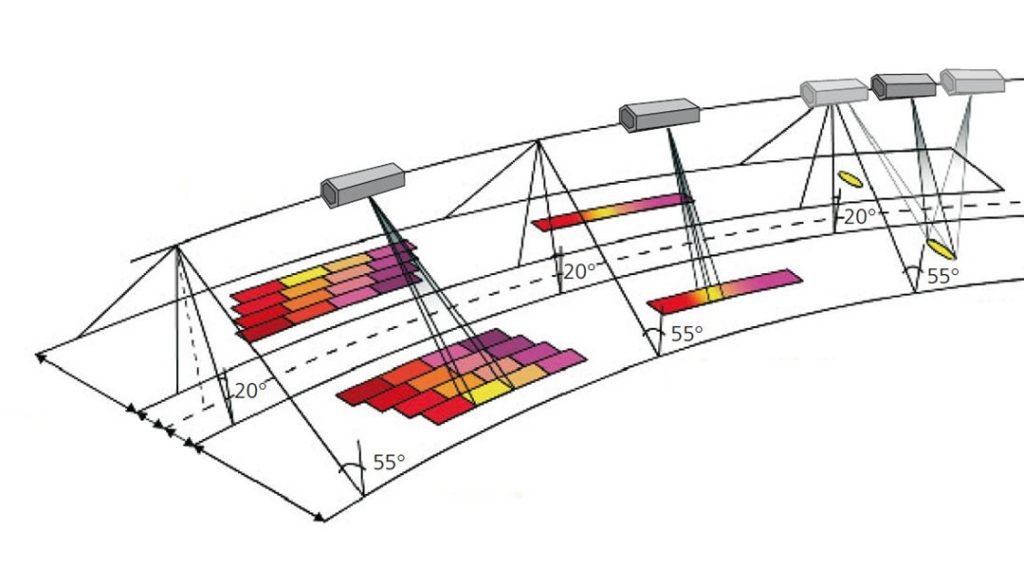
Scan, strip, and spot imaging modes, from left to right. Image credit: German Aerospace Center.

Spot/Spotlight Mode

Spot mode, or Spotlight, concentrates the radar beam on a specific target area by continuously adjusting the antenna's pointing direction.

This technique yields the highest possible spatial resolution but comes at the cost of reduced swath width.

Spot mode is particularly well-suited for detailed analysis of small-scale features, such as infrastructure and object identification.

  • Highest spatial resolution
  • Narrowest swath width
  • Ideal for detailed analysis of small areas

Strip/Stripmap Mode

Strip mode, also known as Stripmap, involves a fixed antenna position as the platform progresses.

This configuration provides a higher spatial resolution than Scan mode while maintaining a reasonable swath width.

Strip mode is commonly used for applications requiring moderate-resolution imagery, such as change detection and disaster response.

  • Higher spatial resolution than Scan mode
  • Moderate swath width
  • Suitable for change detection and disaster response

Scan Mode

In Scan mode, the SAR antenna oscillates back and forth across the area of interest (AOI) as the platform moves forward.

This approach allows for capturing a wide swath of terrain, making it ideal for large-scale mapping and monitoring applications.

While Scan mode offers exceptional coverage, it typically results in lower spatial resolution compared to other modes.  

  • Wide swath coverage
  • Lower spatial resolution
  • Suitable for large-scale mapping and monitoring
What Are the Characteristics of SAR Images?

What Are the Characteristics of SAR Images?

Polarization

Polarization refers to the orientation of the electromagnetic waves transmitted and received by the SAR system. These waves can oscillate horizontally or vertically, leading to four common polarization combinations:

  • VV (Vertical-Vertical): Both transmission and reception are vertical.
  • VH (Vertical-Horizontal): Transmission is vertical, and reception is horizontal.
  • HV (Horizontal-Vertical): Transmission is horizontal, and reception is vertical.
  • HH (Horizontal-Horizontal): Both transmission and reception are horizontal.

Polarization imagery

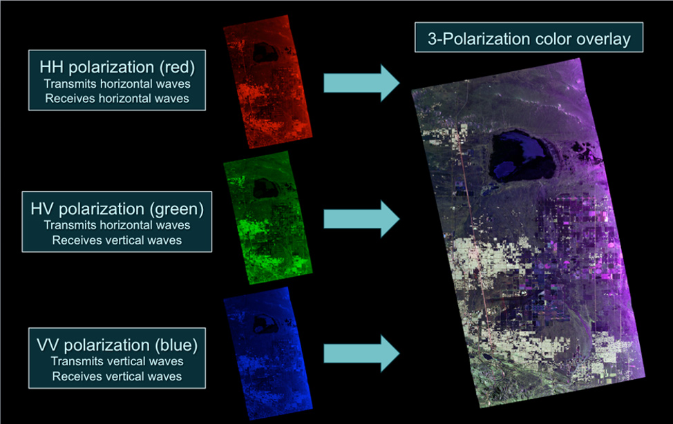
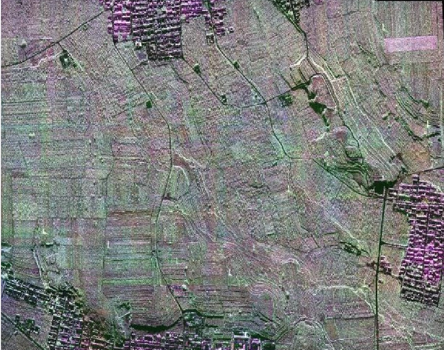
UAVSAR captured this polarimetric image over Rosamond, California. By sending and receiving both horizontal and vertical radar signals, we created three image layers. Combining these layers into a color image reveals detailed surface features. Image credit: NASA/JPL-Caltech

Different SAR systems offer varying capabilities:

  • Single-pol sensors: Transmit and receive in the same polarization (either VV or HH).
  • Dual-pol sensors: Transmit in one polarization but can receive in both the same and the other polarization (VV/VH or HH/HV).
  • Quad-pol sensors: Transmit and receive in both polarizations (VV, VH, HV, HH).

Polarimetry is a sophisticated SAR processing technique that uses these polarization combinations to analyze object properties and their changes over time. Applications include vegetation monitoring, oceanography, geology, and disaster response.

Backscatter Contributors

Backscatter is the portion of the transmitted radar signal that is reflected back to the sensor. Several factors influence backscatter, including wavelength, surface roughness, and scattering mechanisms:

  • Wavelength: The wavelength of the SAR signal affects how deeply it penetrates different surfaces:
  • X-band: Short wavelength, minimal penetration, reflecting mostly from the top canopy in vegetated areas.
  • C-band: Medium wavelength, moderate penetration, useful for detecting structures beneath surface layers like dry sand.
  • L-band: Long wavelength, deep penetration, capturing signals from the ground beneath vegetation, dry alluvium, and ice.
  • Surface Roughness: The roughness of a surface influences the strength of the backscatter signal:
  • Smooth surfaces (e.g., calm water or roads): Reflect signals away from the sensor, resulting in weak returns.
  • Rough surfaces (e.g., rocky terrain): Scatter signals in various directions, producing strong returns.

Scattering Mechanisms:

  • Specular Reflection: Occurs on very smooth surfaces where the signal is reflected away from the sensor, causing minimal backscatter.
  • Diffuse Scattering: This happens on rough surfaces, where the signal is scattered in many directions, leading to strong backscatter.
  • Volume Scattering: Common in objects with multiple layers, like forests, where the signal bounces within the layers, resulting in bright returns.
  • Double Bounce Scattering: Predominantly in urban areas, where radar waves reflect between the ground and vertical structures, creating very strong returns.

Surface Roughness

The surface roughness of an area being imaged significantly impacts the SAR backscatter:

  • Smooth surfaces: These include water or roads where very little signal is scattered back to the sensor.
  • Rough surfaces: Such as vegetation, where backscattered waves go in various directions, resulting in a diffuse backscatter.
  • Human-made structures: Buildings can cause radar waves to double bounce off surfaces, leading to bright and clear backscatter.
  • Objects with multiple layers: Forests or other multilayered objects cause multiple scattering within the object’s internal layers, leading to higher backscatter and a brighter appearance in the SAR image.

Types of scattering

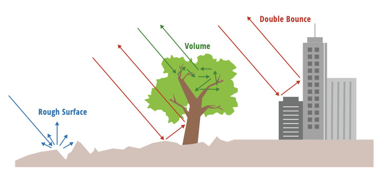
Image Credit: The SAR Handbook

SAR Image Scales

SAR images can be represented in different scales to suit various purposes:

  • Power Scale: Measures the strength of the returned signal. While suitable for statistical analysis, it may require adjustments for proper visualization due to its dynamic range.
  • Amplitude Scale: The square root of power scale values. This scale enhances darker pixels and tones down brighter ones, providing a balanced grayscale display.
  • dB Scale: Calculated by multiplying 10 times the Log10 of the power scale values. It brightens pixels, aiding in differentiating dark features like water bodies from terrestrial ones.

Geometric Distortions

Due to the side-looking nature of SAR sensors, geometric distortions such as foreshortening, layover, and shadow can occur:

  • Foreshortening: Compresses the front slope of a terrain feature, making it appear brighter and narrower.
  • Layover: Projects the front slope's return onto the back slope, misrepresenting the terrain by overlaying data from the front onto the back.
  • Shadow: Results in areas with steep back slopes not being imaged at all, creating regions with no data.

Radiometric terrain correction (RTC) can address foreshortening but not layover or shadow, resulting in areas with no data returns.

Speckle

Speckle is the grainy, salt-and-pepper appearance in SAR images caused by interference among scatterers within the illuminated area. While inherent to SAR, speckles can be mitigated by multi-looking, which averages the signal to smooth the image at the expense of resolution.

Key SAR Parameters

Key SAR Parameters

SAR imagery is a complex dataset influenced by a variety of parameters. Understanding these parameters is crucial for interpreting and effectively utilizing SAR data.

Target Azimuth Angle

This angle defines the position of a target relative to the satellite's flight path. Combined with slant range and elevation angle, it accurately pinpoints target location within the image. Variations in azimuth angle can impact the backscattered signal, affecting image brightness and contrast.  

Grazing Angle

The angle between the radar beam and the Earth's surface, grazing angle determines the steepness of the observation. Higher grazing angles generally provide more image contrast but limit the area covered.  

Slant Range

The direct distance between the radar antenna and a ground point, slant range influences image geometry. Objects at different slant ranges appear displaced due to geometric distortions like layover. Shorter slant ranges often result in higher image resolution but can be affected by noise.

Looks

The number of radar pulses used to form an image. More looks reduce image speckle (noise) but can decrease resolution.

Band

The frequency range of the radar signal affects penetration depth and sensitivity to different surface features. X-band offers high resolution but limited penetration, while L-band penetrates better but has lower resolution.

Bistatic Capability

Employing two satellites for transmission and reception, bistatic SAR provides multiple viewing angles, enhancing image detail and enabling advanced applications like 3D modeling and motion detection.

Amplitude and Phase in SAR Imagery

Synthetic Aperture Radar systems rely on the analysis of two fundamental properties of the radar signal: phase and amplitude. These components work in tandem to provide valuable insights into the Earth's surface.

Amplitude

Amplitude refers to the strength or magnitude of a wave. In the context of SAR, it quantifies the energy returned to the sensor from a target. Areas on the Earth's surface that strongly reflect radar waves will produce high amplitude signals, appearing bright in the resulting image.

Conversely, surfaces with low reflectivity will generate weak signals, appearing dark. This amplitude information is essential for creating grayscale images, which are used for tasks such as mapping, vegetation analysis, and change detection.

Phase

Phase, on the other hand, relates to the timing or position of a wave relative to a reference point. In SAR, the phase difference between the transmitted and received signals is crucial for interferometry.

By comparing the phase of signals acquired at different times or from different positions, it's possible to measure incredibly small changes in the Earth's surface.

This technique is invaluable for applications like topography mapping, deformation monitoring (due to earthquakes, landslides, or subsidence), and precision agriculture.

Applications of SAR Imagery

Applications of SAR Imagery

By harnessing the unique capabilities of SAR, industries, and researchers are gaining unprecedented insights and making informed decisions.

Environmental Monitoring

SAR is pivotal in monitoring our planet's health. Its ability to penetrate clouds and darkness provides invaluable data for tracking deforestation, assessing land cover changes, and mapping natural habitats.

By measuring soil moisture levels and monitoring vegetation health, SAR supports sustainable agriculture and ecosystem management.

Additionally, SAR's capacity to penetrate ice makes it instrumental in studying glaciers, ice caps, and polar regions, contributing to our understanding of climate change.

Disaster Management

In times of crisis, SAR proves to be a lifeline. Its rapid and accurate data acquisition capabilities enable efficient disaster response and recovery efforts.

By mapping affected areas, assessing damage, and monitoring the evolution of disasters, SAR supports humanitarian aid organizations in delivering timely assistance.

Precision Agriculture

SAR technology is transforming the agricultural landscape. By providing insights into crop health, soil moisture, and field conditions, farmers can optimize planting, irrigation, and harvesting practices.

This leads to increased crop yields, reduced resource consumption, and improved food security.

Ku-band SAR imagery with full polarization

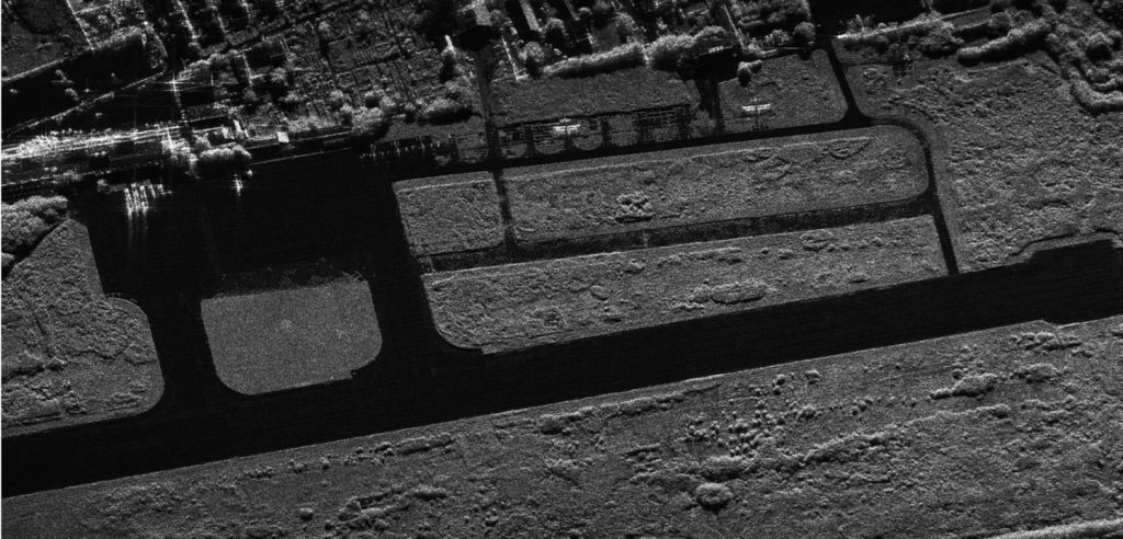
Farmland captured by Ku-band SAR imagery with full polarization. 0.2-meter resolution

Defense and National Security

SAR's all-weather capabilities make it a valuable asset for defense and security applications. It supports surveillance, reconnaissance, and target detection, enabling effective military operations and intelligence gathering.

Furthermore, SAR can be used to monitor critical infrastructure, detect hidden objects, and assess potential threats.

Maritime and Coastal Zone Management

SAR plays a crucial role in maritime operations and coastal zone management. It assists in navigation, monitoring ocean currents and waves, detecting oil spills, and managing fisheries.

By providing valuable data on coastal erosion and sea level rise, SAR supports coastal planning and disaster preparedness.

Urban Planning and Infrastructure

SAR contributes to sustainable urban development by monitoring urban growth, assessing infrastructure conditions, and identifying potential hazards.

Its ability to detect ground subsidence and deformation is essential for maintaining the safety and resilience of urban environments.

FAQ

FAQ

What is Interferometric SAR (InSAR)?

Interferometric Synthetic Aperture Radar (InSAR) is a sophisticated technique that uses multiple SAR images of the same area to create detailed maps of ground deformation. It involves comparing the phase differences between two or more SAR images acquired at different times.

InSAR is widely used in geology, geodesy, and civil engineering for monitoring and studying various geophysical phenomena.

What is the Difference Between Real Aperture Radar and Synthetic Aperture Radar?

Real Aperture Radar (RAR) and Synthetic Aperture Radar (SAR) are both types of radar systems used for remote sensing. The primary difference between them lies in their ability to achieve high resolution.

Real Aperture Radar (RAR):

  • Uses the physical size of the antenna to determine resolution.
  • Limited resolution, especially in the along-track direction.
  • Simpler technology but with significant limitations in image quality.

Synthetic Aperture Radar (SAR):

  • Creates a virtual antenna by processing the radar signals as the platform moves.
  • Achieves much higher resolution than RAR, especially in the along-track direction.
  • More complex technology but provides significantly better image quality.

What is the Difference Between LiDAR and Synthetic Aperture Radar?

LiDAR and SAR are fundamentally different tools for observing the Earth, each with its own strengths and limitations.

LiDAR, relying on laser pulses, excels in precision. It creates highly detailed 3D models by measuring the time it takes for light to bounce back. This makes it invaluable for tasks demanding accurate measurements, such as topography mapping, urban planning, and archaeology.

However, its effectiveness is hindered by weather conditions; clouds and rain can interfere with laser signals.

SAR, on the other hand, employs microwaves. This allows it to penetrate through clouds, making it suitable for all-weather conditions. SAR is adept at large-scale imaging, providing information about land cover, oceanography, and disaster monitoring.

Yet, compared to LiDAR, its spatial resolution is generally lower, resulting in less detailed images.

In essence, LiDAR is akin to a high-resolution camera best used in clear weather for capturing fine details, while SAR is more like a weather-resistant wide-angle lens, capable of seeing through obstacles but offering a less focused view.

What is the Difference Between SAR and ISAR?

SAR

  • Platform-based: The radar system is mounted on a moving platform (aircraft, satellite), and the synthetic aperture is created by the platform's movement.  
  • Targets: Primarily used for imaging stationary objects like terrain, landmasses, and oceans.  
  • Applications: Terrain mapping, environmental monitoring, disaster response, and oceanography.  

ISAR

  • Target-based: The synthetic aperture is created by the movement of the target itself, not the radar platform.  
  • Targets: Primarily used for imaging moving objects like ships, aircraft, and missiles.  
  • Applications: Military surveillance, target identification, and tracking.  

Can Synthetic Aperture Radar See Through Trees?

The ability to see through trees depends on the wavelength of the radar waves used.

Longer wavelengths, like those in L-band SAR, can penetrate deeper into vegetation compared to shorter wavelengths like X-band. However, the image clarity will be affected by the density of the foliage.

While SAR can provide valuable information about forest structure and understory, it doesn't offer the same level of detail as optical images.

Can Synthetic Aperture Radar See Through Trees?

Yes, SAR can penetrate through tree canopies to some extent.  

The ability to do so depends primarily on the wavelength of the radar waves used. Longer wavelengths, such as those in the L-band, can penetrate deeper into vegetation compared to shorter wavelengths like the X-band.  

  • L-band SAR: Often used for forest applications due to its ability to penetrate through dense vegetation and provide information about the forest floor.  
  • X-band SAR: Primarily interacts with the top of the canopy, making it less suitable for penetrating through dense forests.

However, it's important to note that while SAR can provide information about the forest structure and understory, it doesn't provide a clear image like an optical image.

How Does Radar See Through Clouds?

The key to radar's ability to pierce through clouds lies in the wavelength of the microwaves it employs. These waves are significantly larger than the particles that compose clouds, such as water droplets.

As a result, the microwaves can pass through the cloud without being significantly deflected or absorbed. This is similar to how radio waves can penetrate walls while visible light cannot.

Why Do Radar Data and Images Often Lack Color?

Radar images typically appear in grayscale because they primarily measure the strength of the returned signal. This strength, or intensity, is represented by varying shades of gray.

What's the Smallest Object You can See in a SAR Image?

Typically, the smallest detail you can see in a standard SAR image is about 30 meters across. This means large objects like ships and their trails are easy to spot. However, there are exceptions.

Long, thin things like roads or pipelines can sometimes show up, even if they're narrower than 30 meters, depending on how the radar is looking at them. Also, small but very reflective objects, like certain buildings, might appear as bright dots in the image, even if they're smaller than the usual detail level.

It's possible to use special techniques to make smaller things more visible in SAR images.

Share :
Read More
thumbnail
In satellite navigation, GPS and GNSS are often used interchangeably, but they refer to different technologies. GPS, developed by the U.S., is just one of several satellite systems, while GNSS include
thumbnail
Ever found yourself lost in a strange city, trying to explain your location to a friend? Understanding location is a fundamental human skill, and there are two primary ways to pinpoint a place on Eart
thumbnail
Cargo theft has escalated into a critical issue, with recent data highlighting a staggering 46% increase in incidents during the first quarter of 2024 compared to the previous year, according to Cargo