Ever wondered how airplanes stay stable in turbulent skies, how drones maintain perfect aerial shots, or how autonomous vehicles navigate complex environments with unwavering accuracy?
Simply put, AHR
What is Hyperspectral Imaging?
Imagine a camera that could not only see the colors we can, but also detect the subtle differences in light that our eyes miss. That's the power of hyperspectral imaging (HSI).
Unlike traditional cameras, which capture images in just three color bands (red, green, and blue), HSI systems break down light into hundreds or even thousands of individual wavelengths. This allows them to "see" beyond the visible spectrum and identify materials based on their unique spectral signatures.
From satellites in space to drones flying overhead, HSI systems can be mounted on various platforms to serve a wide range of applications. Whether it's monitoring vegetation health, detecting environmental hazards, or identifying hidden objects, HSI offers a level of detail and precision that's simply unmatched.
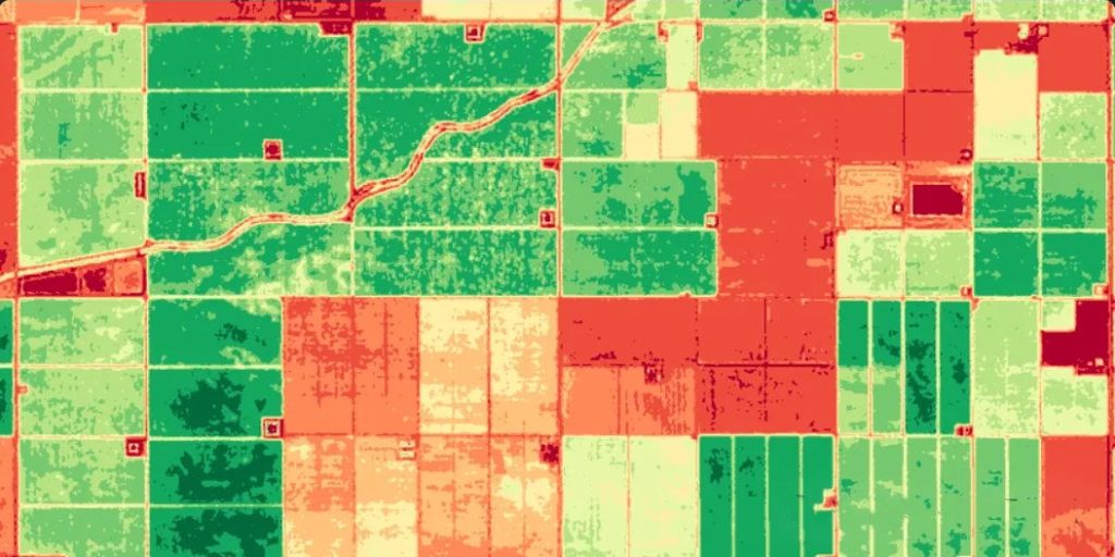
Image credit: eos.com
How Does Hyperspectral Imaging Work?
The core of hyperspectral imaging lies in the use of an imaging spectrometer, often referred to as a hyperspectral camera. This specialized device captures light reflected or emitted from a scene.
1. Capturing and Separating Light
As light enters the hyperspectral camera, it is dispersed into various spectral bands. This separation is achieved using optical elements like prisms or diffraction gratings. Each band represents a specific range of wavelengths, which allows the camera to record detailed information about how each part of the scene interacts with light.
2. Creating the Hyperspectral Image
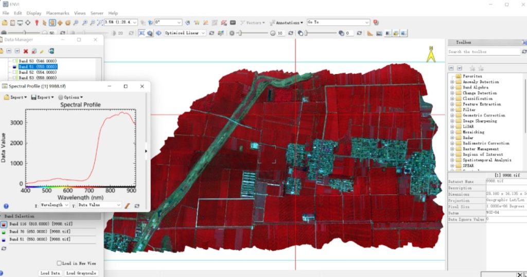
The hyperspectral camera simultaneously captures both the spatial and spectral data of the scene. This results in a two-dimensional image where each pixel contains a unique spectrum—a detailed representation of the light reflected from that specific point in the scene. This spectrum acts as a "fingerprint" for the materials present.
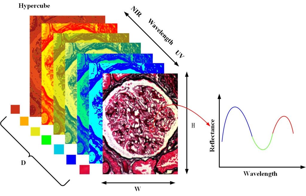
3. Generating the Data Cube
The output of a hyperspectral imaging system is often visualized as a hyperspectral data cube. This cube has three dimensions: two spatial dimensions (x and y) corresponding to the scene's layout, and one spectral dimension (z) that represents the range of wavelengths captured.
Each layer of the cube corresponds to a different spectral band, and each pixel within these layers holds detailed spectral information.
4. Analyzing Spectral Signatures
Each material in the scene reflects, absorbs, and emits light differently, creating a unique spectral signature. These signatures are akin to fingerprints for materials. By analyzing these spectral fingerprints, hyperspectral imaging can accurately identify and quantify the materials present.
For example, the technology can distinguish between different types of vegetation, detect specific minerals, or identify chemical contaminants.
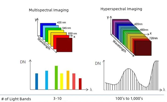
Number of Spectral Bands
The most notable difference between hyperspectral and multispectral imaging lies in the number of spectral bands they capture. Multispectral imaging (MSI) typically involves capturing data in a limited number of broad spectral bands, usually ranging from 3 to 10. These bands often include visible light (red, green, blue) and a few near-infrared bands.
Hyperspectral imaging (HSI), on the other hand, captures data in hundreds or even thousands of narrow spectral bands. This extensive band coverage allows hyperspectral sensors to detect subtle differences in the spectral signatures of materials, making it possible to identify and quantify specific substances.
Spectral and Spatial Resolution
HSI offers a high spectral resolution, meaning it can distinguish between very close wavelengths, which is essential for detailed material analysis. However, this high spectral resolution often comes at the expense of spatial resolution, which may be lower compared to multispectral systems.
MSI provides broader spectral data with fewer bands, which is generally sufficient for applications that require less detailed spectral information but demand higher spatial resolution.
Data Processing and Complexity
Due to the large number of bands and the detailed data captured, hyperspectral imaging requires complex and resource-intensive data processing. Specialized software and expertise are needed to interpret hyperspectral data accurately.
Multispectral imaging, with its fewer bands, generates less complex data, making it easier and faster to process. This makes multispectral imaging suitable for applications requiring quick or real-time analysis.
Cost and Accessibility
Hyperspectral imaging is generally more expensive due to the complexity of the sensors and the extensive data processing required. It is often reserved for scientific research and specialized applications where detailed material information is critical.
Multispectral imaging is more affordable and widely accessible, making it a popular choice for a broader range of industries, including agriculture, forestry, and environmental monitoring.
Dependence on Atmospheric Conditions
Hyperspectral imaging is more sensitive to atmospheric conditions and requires careful calibration, which can limit its use in certain environments.
In contrast, multispectral imaging is less affected by atmospheric interference, making it more versatile for a wide range of remote sensing applications.
What Information Hyperspectral Imaging Provides?
By combining the benefits of digital imaging and spectroscopy, hyperspectral imaging offers spatial and spectral data, enabling us to identify, classify, and understand objects and materials in unprecedented detail.
- Spectral Signatures: Each material or substance has a unique way of interacting with light, known as its spectral signature. Hyperspectral imaging captures these signatures across hundreds or even thousands of wavelengths, allowing precise identification of materials. For example, it can differentiate between various types of vegetation, and minerals, or even detect contaminants in food.
- Molecular Analysis: By analyzing the spectral data, hyperspectral imaging can determine the chemical composition of a material. This is crucial in applications like agriculture, where it can identify nutrient levels in plants, or in pharmaceuticals, where it can ensure the correct chemical composition of drugs.
- Location and Extent: Beyond just identifying materials, hyperspectral imaging also provides spatial information about where these materials are located within the image. This is useful in surveying applications, environmental monitoring, or any scenario where understanding the distribution of materials across a surface is important.
- Monitoring Over Time: Hyperspectral imaging can track changes over time by capturing images at different intervals. This allows for monitoring the progression of processes, such as plant growth, the spread of pollution, or changes in material properties under varying conditions.
- Beyond RGB: While traditional imaging uses just three bands (red, green, blue) to create a visual representation, hyperspectral imaging captures hundreds of bands, providing a much richer and more detailed picture. This extra detail can reveal subtle differences that are invisible to the human eye, enabling more thorough analysis and interpretation.

Food Quality and Safety
Hyperspectral imaging plays a pivotal role in ensuring the safety and quality of food products. Analyzing the spectral signatures of food items can detect contaminants, assess ripeness and quality, detect adulteration, identify allergens, and detect pesticide residues. This technology helps safeguard consumers from potential health risks and ensures that only the highest quality products reach the market.

Environmental Monitoring
Hyperspectral imaging is a valuable tool for monitoring environmental conditions and detecting issues such as water quality, vegetation health, coastal monitoring, pollution detection, and land cover mapping. By analyzing the spectral signatures of various environmental elements, it can provide valuable insights into the health of ecosystems, identify pollution sources, and track changes in land use patterns.

Mining and Prospecting
In the mining and prospecting industry, hyperspectral imaging aids in mineral exploration, ore grade estimation, alteration mapping, geological mapping, and environmental monitoring. By analyzing the spectral signatures of minerals and geological features, it can help identify potential mineral deposits, assess their quality, and monitor the environmental impacts of mining operations.

Precision Agriculture
Hyperspectral imaging revolutionizes agriculture by enabling farmers to monitor crop health, predict yields, manage irrigation, detect and control weeds, and optimize nutrient management. By analyzing the spectral signatures of plants and soil, it provides valuable data for making informed decisions and improving agricultural productivity.

Infrastructure Inspection
Hyperspectral imaging is used to assess the condition of infrastructure, including bridges, pipelines, buildings, and roads. Analyzing the spectral signatures of materials can detect defects, such as cracks, corrosion, and delamination, and identify areas that require maintenance or repair.

Defense and Security
In defense and security applications, hyperspectral imaging offers capabilities such as target identification and classification, surveillance and reconnaissance, counter-terrorism, and maritime security. By analyzing the spectral signatures of objects and environments, it can provide valuable intelligence, detect threats, and ensure security.

Research and Development
Hyperspectral imaging is a valuable tool for researchers in various fields, including material science, biology, chemistry, environmental science, forensic science, and art conservation. By analyzing the spectral signatures of materials, biological samples, and chemical compounds, it can provide insights into their properties, composition, and characteristics.

Pharmaceuticals and Biomedical Research
In pharmaceuticals and biomedical research, hyperspectral imaging contributes to drug development, quality control, and biomedical research. By analyzing the spectral signatures of biological samples and chemical compounds, it can help identify diseases, develop new medications, and optimize drug delivery.

Color Measurement
Hyperspectral imaging is used for accurate color measurement in various industries, including printing, textiles, paints, and coatings. By analyzing the spectral signatures of colors, it can ensure consistency, match colors, and establish color standards.
Read More

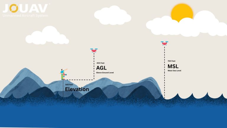
In aviation, precision isn’t just a goal—it’s a necessity. Every altitude reading, flight path, and safety protocol hinges on understanding two critical measurements: Mean Sea Level (MSL) and Above Gr

So, you’re wondering if you can fly your drone in the rain. The answer is generally a resounding NO. Most drones—especially consumer models like the DJI Mini or Air series—aren’t waterproof.
Rai

JOUAV Product News and Use Cases
Fixed-Wing VTOL Drones Insights and Industry Trends
Invitations to online demo events