You glance at the METAR report:
KJFK 031452Z 28022G35KT 1/4SM +TSRA OVC005CB 18/16 A2987 RMK AO2
It looks like aviation’s secret code—and you’re not alone if you feel overwhelmed.
Many avi
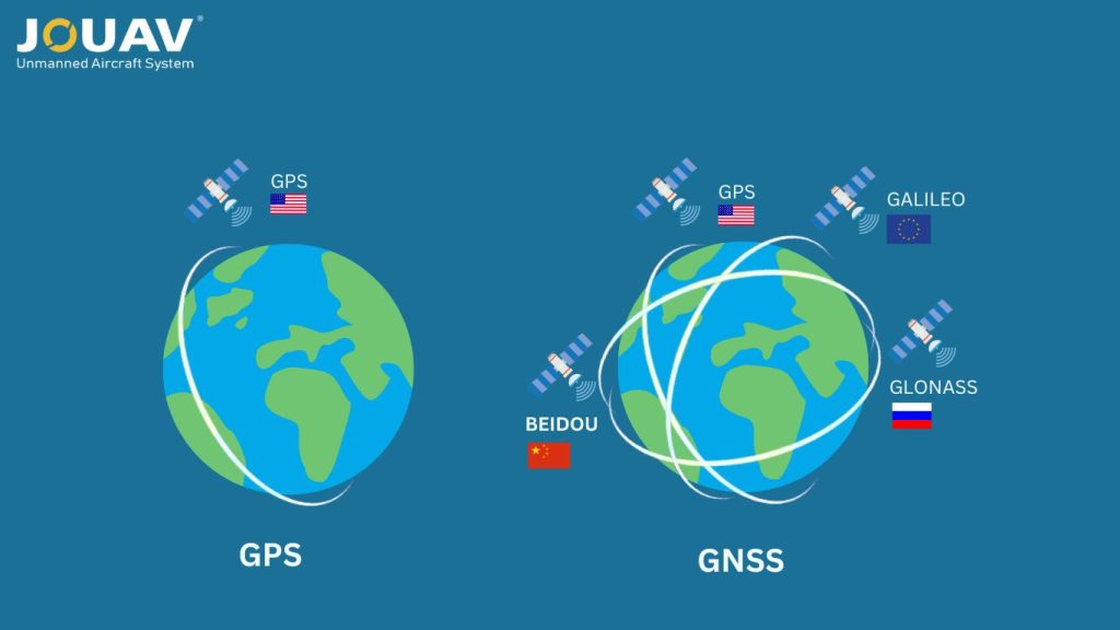
In satellite navigation, GPS and GNSS are often used interchangeably, but they refer to different technologies.
GPS, developed by the U.S., is just one of several satellite systems, while GNSS includes multiple constellations like GPS, GLONASS, and Galileo, providing wider coverage and improved accuracy.
In this article, we’ll explore the key differences between GNSS and GPS, their working principles, and how they are applied in everyday life.
Scope and Coverage
Since GNSS includes multiple satellite systems from around the world, its coverage is truly global, extending even to remote areas. It provides more comprehensive and reliable coverage across different regions and environments, thanks to the combined constellations.
While GPS offers near-global coverage, its primary focus is on North America and the Pacific region, where its satellite constellation is most optimized. In other parts of the world, especially in areas with obstacles or remote locations, its performance might be slightly less reliable compared to GNSS.
Accuracy and Reliability
GNSS generally offers better accuracy than GPS. While GPS is accurate to around 5-10 meters, GNSS can get you as close as 1-2 meters or even better under ideal conditions. This is because GNSS pulls data from multiple satellite systems, which gives it more options for positioning and improves precision.
GNSS also uses more advanced algorithms to correct for things like atmospheric interference and satellite clock drift, which helps refine location accuracy.
Plus, unlike GPS, which mainly uses L1 and L2 frequencies, GNSS operates on a wider range of frequencies like L1, L2, L5, and E5, making it more adaptable to different conditions, especially when dealing with atmospheric disturbances.
On top of that, modern GNSS receivers often come with features like multi-constellation tracking, real-time kinematic (RTK) accuracy, and differential corrections from base stations, all of which further improve positioning accuracy.
Signal Availability and Visibility
GNSS is more robust because it pulls data from multiple satellite constellations, which helps reduce the risk of signal loss and improves overall availability.
If one system runs into interference or goes offline, the receiver can switch to other constellations, ensuring that coverage remains continuous. This ability to access multiple systems also enhances signal visibility, making GNSS less prone to obstructions like buildings or thick foliage.
With satellites spread across different parts of the sky, the impact of physical barriers is minimized, leading to more reliable positioning.
In contrast, GPS relies on a single constellation, making it more vulnerable to signal interruptions, especially in challenging environments. Its availability can be compromised by interference, jamming, or natural obstacles like mountains and forests, which makes it less reliable than GNSS.
Additionally, GPS signals are easier to block by things like buildings and trees, particularly in urban areas or dense woods, which can hurt both performance and accuracy.
Applications
GNSS is used globally for both military and civilian purposes. Its various systems support a wide range of applications across sectors like transportation, agriculture, environmental monitoring, and precision mapping. The global reach of GNSS makes it ideal for anyone needing accurate positioning information anywhere on Earth.
Originally developed for military use, GPS has become essential for civilians too. Today, it’s commonly found in cars, smartphones, and aviation. Many industries, including logistics, emergency services, and recreational activities, rely on GPS. While it still plays a crucial role in military operations, its civilian applications have grown significantly over the years.
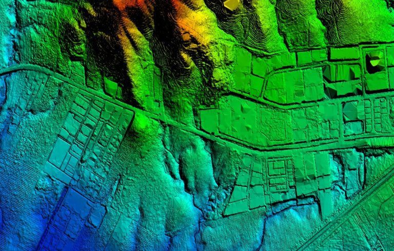
How is GPS Used for Surveying?
GPS technology has revolutionized the surveying industry by offering unmatched precision and efficiency compared to traditional methods. Unlike everyday GPS devices, surveying GPS receivers are equipped with specialized antennas and utilize dual-frequency signals to ensure superior accuracy.
How Does Surveying GPS Work?
To determine precise distances and elevations, surveyors use a pair of GPS receivers. These devices are placed at opposite ends of a measurement line and simultaneously collect data from the same satellites. By comparing the measurements from both receivers, surveyors can calculate differences in latitude, longitude, and elevation between the two points.
The Benefits of GPS Surveying
- Unrestricted Operation: GPS technology allows surveyors to work in virtually any location with a clear view of the sky. This flexibility is especially advantageous in remote areas or environments with limited visibility, such as coastlines and waterways.
- Enhanced Accuracy: GPS provides highly accurate positional data, making it ideal for various applications, including hydrographic surveys, offshore oil rig projects, and bridge construction.
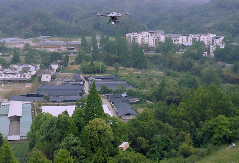
- Versatile Applications: GPS technology can be integrated with drones, such as the JOUAV CW-15, to capture aerial imagery and data, enabling more efficient and comprehensive surveys of large areas. This GPS drone is particularly useful for topographic mapping, environmental monitoring, and disaster response.

Read More

How much weight can a drone fly?
Here is the answer: Physically, consumer drones can carry 0.2 kg to 2 kg (0.4–5.5 lbs), while heavy-lift models like the CW-80E handle up to 25 kg (55 lbs). Industria
In 2018, researchers in Guatemala used airborne lasers to expose over 60,000 hidden Maya structures—farmsteads, fortresses, and even highways—transforming our understanding of one of history’s m

JOUAV Product News and Use Cases
Fixed-Wing VTOL Drones Insights and Industry Trends
Invitations to online demo events