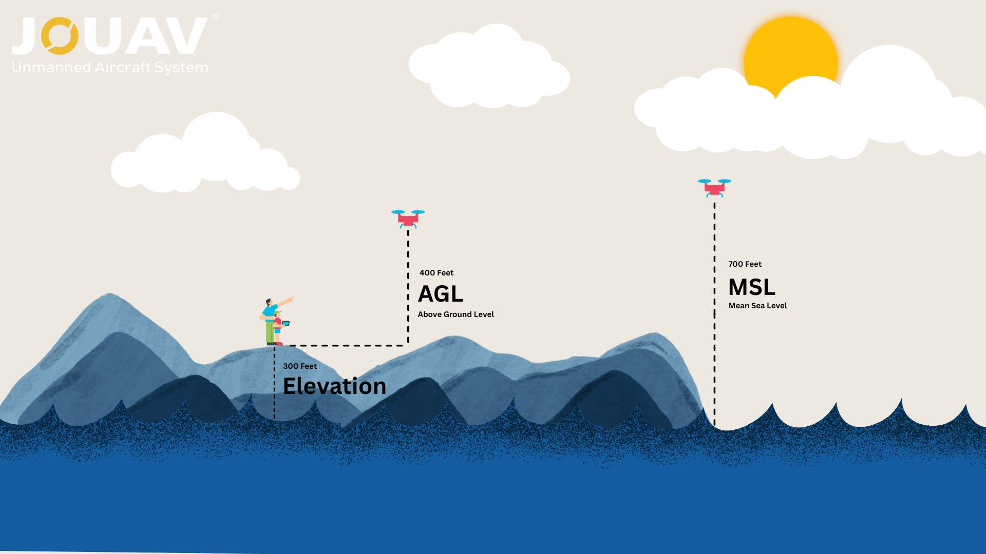
In aviation, precision isn’t just a goal—it’s a necessity. Every altitude reading, flight path, and safety protocol hinges on understanding two critical measurements: Mean Sea Level (MSL) and Above Ground Level (AGL). These terms define how pilots, drone operators, and engineers interpret altitude, and confusing them can lead to catastrophic errors.

What’s the Difference?

  • MSL (Mean Sea Level): Your altitude relative to the global average sea level. It’s a fixed reference used worldwide.
  • AGL (Above Ground Level): Your height above the terrain directly beneath you. It’s a dynamic measurement that changes with the landscape.

AGL vs. MSL

Since the ground itself often sits hundreds or thousands of feet above sea level (a value called elevation), MSL altitudes are typically higher than AGL.

For example, a drone flying 400 feet AGL over Denver, Colorado (elevation: 5,280 ft MSL) is actually at 5,680 ft MSL—a distinction with life-or-death implications.

In 2022, a drone pilot learned this the hard way. He was fined $10,000 by the FAA after misreading his altimeter: flying at 400 ft MSL over mountainous terrain meant his drone was 600 feet below the legal AGL limit.

This guide dives into the difference between AGL and MSL, how to avoid costly mistakes, and how these concepts shape aviation, drones, and beyond.

What is AGL (Above Ground Level)?

What is AGL (Above Ground Level)?

AGL, or Altitude Above Ground Level, refers to the height of an object measured from the ground surface directly beneath it. Unlike fixed reference systems, AGL is inherently dynamic, changing based on the underlying terrain.

For instance, a drone flying at 400 feet AGL over a mountain ridge is 400 feet above that ridge’s surface—even if the ridge itself is already thousands of feet above sea level.

AGL is commonly measured using tools such as radar altimeters, LiDAR sensors, or onboard drone sensors that detect distance from the surface below in real time.

When to Use AGL?

In aviation, AGL is used for terrain-following approaches and helicopter operations in complex environments, such as urban areas or mountainous regions.

The FAA’s drone regulations are also grounded in AGL. According to FAA Part 107, drones must stay within 400 feet AGL unless flying within a 400-foot radius of a structure and not exceeding its height.

Beyond aviation, AGL is relevant in industries such as construction and mining. Knowing the exact height above the local surface is essential when operating cranes, blasting in mines, or conducting aerial inspections.

What is MSL (Mean Sea Level)?

What is MSL (Mean Sea Level)?

MSL, or Mean Sea Level, is a global reference system that measures altitude based on the average sea level over time. Unlike AGL, which depends on local topography, MSL is a fixed reference point that provides consistency in altitude reporting across different locations and altitudes.

For example, Mount Everest is recognized as being approximately 29,032 feet MSL, regardless of the terrain surrounding it or the instruments used to measure elevation.

MSL is typically determined using barometric altimeters and GPS technology. Barometric altimeters estimate altitude based on atmospheric pressure, which changes with height, while GPS-based systems calculate elevation using satellite signals.

When to Use MSL?

In commercial aviation, MSL is the standard for reporting cruising altitudes. For example, when an aircraft flies at 35,000 feet, that refers to 35,000 feet above mean sea level—not above the ground below. This uniformity allows air traffic control to maintain safe vertical separation between aircraft worldwide.

Outside of aviation, MSL is central to disciplines like climate science, oceanography, and geospatial surveying. Government agencies, including NOAA, use MSL data to track long-term sea-level changes, assess coastal flood risks, and inform climate policy.

Surveyors and engineers rely on MSL when creating topographic maps or determining land elevations for construction and floodplain management.

AGL vs MSL: Key Differences

AGL vs MSL: Key Differences

AspectAGLMSL
Reference PointGround below objectGlobal sea level average
VariabilityChanges in terrainFixed
MeasurementRadar altimeters, dronesBarometric altimeters, GPS
Primary UseObstacle avoidance, local opsAviation, climate models
RegulationsFAA Part 107 (drones)ICAO flight paths

The interplay between AGL and MSL becomes clear in scenarios like mountain flying. A plane departing Denver (elevation: 5,280 feet MSL) might climb to 10,000 feet MSL, but its AGL altitude—the actual height above the ground—is only 4,720 feet. Conversely, a drone pilot in Miami (elevation: 6 feet MSL) flying at 400 feet AGL operates at 406 feet MSL.

Misinterpreting these references can have dire consequences. A pilot assuming a 5,000-foot MSL altitude guarantees safe terrain clearance in the Rockies might collide with a 6,000-foot MSL mountain peak. Similarly, a drone operator confusing AGL with MSL risks flying illegally low over elevated terrain.

AGL vs MSL on Sectional Charts

AGL vs MSL on Sectional Charts

Sectional charts are essential tools for pilots and drone operators, providing critical details about terrain, obstacles, and airspace. One of the most common—and trickiest—elements to interpret is the dual altitude labeling for obstacles like towers, buildings, and mountain peaks.

But to use them effectively, you must decode one critical detail: how altitudes are labeled.

Here’s the golden rule:

  • MSL (Mean Sea Level): All numbers on sectional charts are MSL unless they’re in parentheses.
  • AGL (Above Ground Level): Values in parentheses indicate height above the terrain directly below.

For example, a tower on a sectional chart might be labeled 5,138 (MSL) with (356) in parentheses (AGL). This means the tower’s peak is 247 feet above the ground and 5,138 feet above sea level.

AGL vs MSL on sectional charts

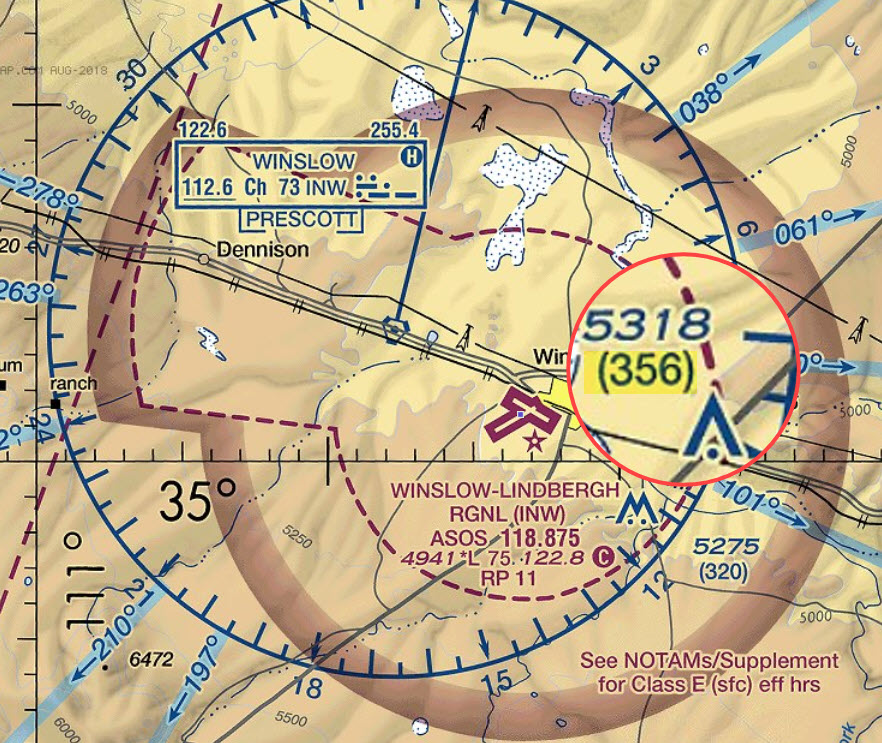
During your FAA exam, you’ll have access to the Sectional Aeronautical Chart legend (located after the Table of Contents). This legend decodes symbols like obstruction icons and clarifies altitude labeling. If you’re unsure whether a number is AGL or MSL, check the parentheses rule: No parentheses = MSL; parentheses = AGL.

How to Convert AGL to MSL (and Vice Versa)?

How to Convert AGL to MSL (and Vice Versa)?

Converting between AGL and MSL is essential for safe navigation, whether you’re flying a drone, piloting an aircraft, or mapping terrain. The process hinges on one critical value: ground elevation (the height of the terrain above sea level).

The Core Formulas

1. AGL to MSL:

MSL = AGL + Ground Elevation

2. MSL to AGL:

AGL = MSL − Ground Elevation

Step 1: Find the Ground Elevation

Ground elevation is the height of the terrain (in MSL) at your location. You can get this from:

  • FAA Sectional Charts (labeled for airports, towers, and terrain).
  • Google Earth (type coordinates or search a location).
  • Aviation apps like ForeFlight or Airmap.

Example:

In Denver, Colorado, the ground elevation is 5,280 ft MSL.

Step 2: Apply the Formula

Scenario 1: Converting AGL to MSL

You’re flying a drone at 400 ft AGL over Denver.

  • Formula: MSL = 400 ft (AGL) + 5,280 ft (ground elevation).
  • Result: 5,680 ft MSL.

Scenario 2: Converting MSL to AGL

A pilot cruising at 10,000 ft MSL over Denver wants to know their AGL.

  • Formula: AGL = 10,000 ft (MSL) – 5,280 ft (ground elevation).
  • Result: 4,720 ft AGL.
FAQ

FAQ

What Does 500 AGL Mean?

500 AGL means an object (aircraft, drone, etc.) is flying 500 feet above the ground directly beneath it.

Which is Higher, MSL or AGL?

Generally, MSL is higher than AGL. MSL is the altitude above the average level of the world's oceans, while AGL is the altitude above the ground directly beneath the aircraft. Since the ground is almost always above sea level (except for underwater areas), MSL readings will typically be higher.

How Does Weather Affect MSL Measurements?

Weather impacts MSL measurements primarily through atmospheric pressure and temperature changes. Low-pressure systems cause altimeters to overread MSL altitude, potentially misleading pilots about their true height.

Temperature also plays a role: cold air increases air density, making true altitude lower than indicated, while hot air reduces density, raising true altitude. Pilots adjust altimeters using local barometric pressure (QNH) to correct these discrepancies, ensuring accurate MSL readings for safe navigation.

Is MSL the Same as Elevation?

No, MSL is not the same as elevation, though they are related. MSL is the reference point for measuring elevation. Elevation is the vertical distance of a point or object above or below MSL.

What is the Difference Between Altitude and MSL?

In broad terms, "altitude" refers to the vertical distance of an object above a reference point. However, that reference point can change.

MSL is a specific type of altitude. It's the altitude measured relative to the average level of the world's oceans. It provides a consistent, global reference point.

Is Elevation the Same as Sea Level?

No, elevation and sea level are not the same; elevation is measured relative to sea level. Sea level is the average height of the ocean's surface, while elevation is the height of a land or geographic feature above that reference level. Think of it this way: the sea level is the baseline, and elevation is the distance something is above or below that baseline.

Is Altitude Elevation Above Sea Level?

Yes, altitude is commonly used as a synonym for elevation, referring to the height of something above sea level.

What is the Highest Point Above MSL?

The highest point above mean sea level (MSL) is the summit of Mount Everest, located on the border of Nepal and China, at 8,848 meters (29,029 feet).

Does the Altimeter Read in AGL or MSL?

An altimeter primarily reads in MSL. When the altimeter is properly set with the local barometric pressure, it displays the altitude of the aircraft above sea level.

While AGL is also a relevant altitude measurement, it's not directly displayed by a standard altimeter. A separate instrument, like a radio altimeter, is used for AGL readings, especially at lower altitudes.

Is Metar in AGL or MSL?

In METAR reports, cloud heights are typically reported in Above Ground Level (AGL). This is crucial for pilots to understand the distance between the cloud base and the ground, especially during takeoff and landing.

Therefore, when a METAR report says "OVC040" that means an overcast cloud layer at 4000 feet above the ground level of that reporting station.

Do Commercial Pilots Use AGL or MSL?

Commercial pilots use both AGL and MSL, depending on the flight phase. During takeoff, landing, or low-altitude maneuvers, AGL is crucial for obstacle clearance and terrain awareness. For example, maintaining 1,000 feet AGL over cities ensures safety.

At cruising altitudes, MSL is used to adhere to standardized flight levels (e.g., 35,000 feet MSL), enabling global coordination and collision avoidance. Pilots rely on radar altimeters for real-time AGL data during approach and barometric altimeters set to MSL for en-route navigation.

Are Approach Plates AGL or MSL?

On an approach plate, altitudes are typically displayed in terms of MSL (Mean Sea Level), while heights are often expressed in AGL (Above Ground Level). MSL represents the aircraft's altitude relative to the average sea level, while AGL refers to its height above the terrain directly below.

Are Airport Elevations in AGL or MSL?

Airport elevation, also known as field elevation or runway elevation, is always defined and measured in relation to Mean Sea Level (MSL), not Above Ground Level (AGL).

Is Airspace Depicted in MSL or AGL?

Airspace is generally depicted on aeronautical charts using MSL, not AGL. While some charts may also include AGL altitudes in parentheses for specific features like towers, the primary altitude reference for airspace is MSL.

Share :
Read More
thumbnail
So, you’re wondering if you can fly your drone in the rain. The answer is generally a resounding NO. Most drones—especially consumer models like the DJI Mini or Air series—aren’t waterproof. Rai
thumbnail
With their six-propeller design, hexacopters stand out for their stability, payload capacity, and flight redundancy. This makes them a powerful choice for aerial photography, precision agriculture, in
thumbnail
什么是地震勘测? What is a Seismic Survey? A seismic survey is a geophysical technology that uses sound waves to create detailed images of the Earth’s subsurface. By analyzing the way these wa